2016 · GS Paper 1 · Q19 · 12 marks
Enumerate the problems and prospects of inland water transport in India.
In short
Inland water transport offers cheap, low-carbon bulk freight, regional links and river tourism, but seasonal depth, siltation, barrages and weak terminal networks keep its freight share small. Cargo on National Waterways rose from about 18 million tonnes in 2013-14 to over 145 million tonnes in 2024-25.
Model answer
Ghissu Editorial · Verified 4 Oct 2026 · 282 words
Cheap, green freight
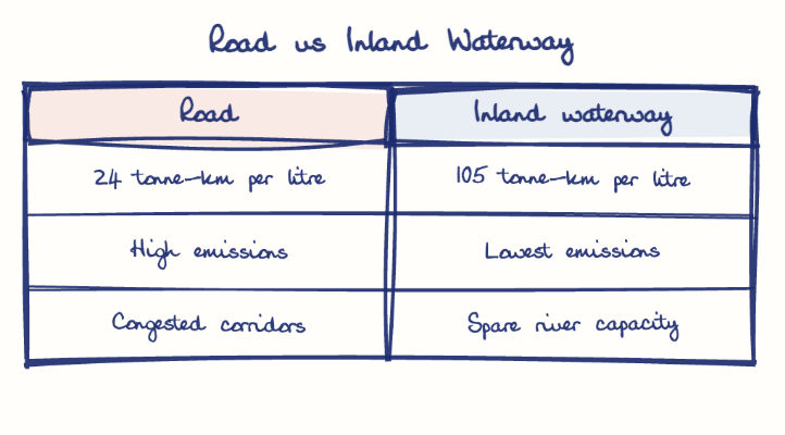
That efficiency suits bulk coal, cement and grain and supports the National Logistics Policy (2022) and net zero 2070.
Jal Marg Vikas
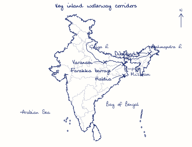
The World Bank-aided project gave NW-1 multimodal terminals at Varanasi, Sahibganj and Haldia and a new Farakka lock.
Regional links and tourism
The Indo-Bangladesh Protocol Route reaches the North East, Kaladan uses Sittwe port (2023), and the Ganga Vilas cruise (2023) showed tourism potential.
Seasonal depth
Rivers lose depth in the lean season, so many of the 106 new waterways cannot carry year-round cargo.
Siltation
Heavy silt in the Ganga and Brahmaputra makes dredging costly and disturbs Gangetic dolphins in the Vikramshila sanctuary.
Physical breaks
Barrages, low bridges and power lines without locks or clearance interrupt routes, and irrigation withdrawals cut lean-season flow.
Weak ecosystem
Few linked terminals, small fleets, scarce return cargo and slow transit keep freight on road and rail.
This model answer is indicative and the model can make mistakes; please verify key facts independently.
Practise this question
1Get the answer sheet
Sized for this question.
2Write your answer
Timed, by hand.
3Get it marked
Your score and what to fix.
This chapter in the exam
Indian Trade / Transport4 questions
Asked in 3 of 14 sittings since 2013
- 2019How is efficient and affordable urban mass transport key to the rapid economic development in India?
- 2016South China Sea has assumed great geopolitical significance in the present context. Comment.
All 4 questions, sorted by sub-topic, with model answers and practice.
Question from the official UPSC Civil Services (Main) Examination 2016 paper. Answer written by Ghissu's engine and checked against our editorial standards. Found an error? Tell us and we correct it within 48 hours.