2016 · GS Paper 3 · Q15 · 12 marks
The frequency of urban floods due to high intensity rainfall is increasing over the years. Discussing the reasons for urban floods, highlight the mechanisms for preparedness to reduce the risk during such events.
In short
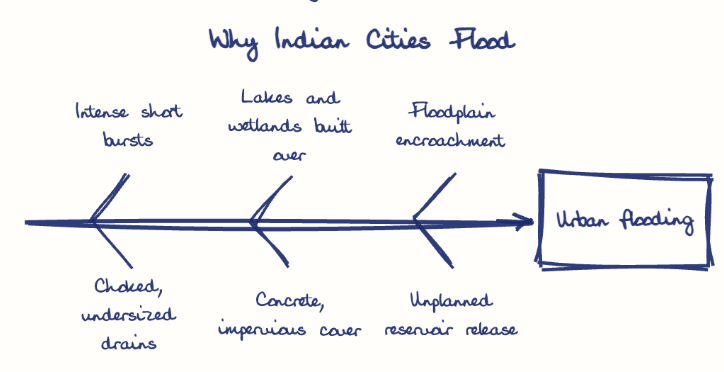
Urban floods are rising because heavier rain bursts meet undersized, choked drains and cities built over lakes, wetlands and floodplains. Preparedness rests on NDMA's 2010 Urban Flooding Guidelines, ward-level plans, early warning such as IFLOWS-Mumbai, drainage upgrades and sponge-city restoration.
Model answer
Ghissu Editorial · Verified 4 Oct 2026 · 295 words
Heavier, shorter rainfall
A warmer atmosphere and the urban heat island concentrate rain into intense bursts over the city core.
Drains built for another era
Storm drains cover only about 20% of urban roads (MoUD, 2011), and Mumbai's colonial drains were sized for about 25 mm an hour, then choked by plastic and silt.
Lost natural sponges
Chennai built over the Pallikaranai marsh, and Delhi's built-up area rose from 20% in 1985 to 52% in 2018 (NIDM, 2025), so more rain runs off.
Mismanaged releases
The late, bulk release from Chembarambakkam reservoir deepened Chennai's 2015 flood.
Institutional plan
NDMA's Urban Flooding Guidelines (2010) seek ward-level contingency plans, now backed by Urban Disaster Management Authorities under the DM (Amendment) Act 2025.
Early warning
Doppler radars, dense rain gauges and IFLOWS-Mumbai (2020) give ward-wise inundation forecasts.
Drainage upgrades
Pre-monsoon desilting and higher design standards, as Mumbai's BRIMSTOWAD project raised drain capacity towards 50 mm an hour.
Sponge city and community
Restored lakes, rainwater harvesting and trained ward volunteers cut runoff and response time.
This model answer is indicative and the model can make mistakes; please verify key facts independently.
Practise this question
1Get the answer sheet
Sized for this question.
2Write your answer
Timed, by hand.
3Get it marked
Your score and what to fix.
This chapter in the exam
Urban Floods2 questions
Asked in 2 of 14 sittings since 2013
Question from the official UPSC Civil Services (Main) Examination 2016 paper. Answer written by Ghissu's engine and checked against our editorial standards. Found an error? Tell us and we correct it within 48 hours.