2015 · GS Paper 3 · Q11 · 12 marks
What do you understand by 'Standard Positioning Systems' and 'Precision Positioning Systems' in the GPS era ? Discuss the advantages India perceives from its ambitious IRNSS programme employing just seven satellites.
In short
Standard Positioning is GPS's open civilian signal and Precision Positioning its encrypted dual-frequency military tier, and IRNSS gives India its own version of both. Its three geostationary and four geosynchronous satellites stay visible over India, giving strategic autonomy after the reported GPS denial during Kargil in 1999.
Model answer
Ghissu Editorial · Verified 4 Oct 2026 · 303 words
Standard Positioning
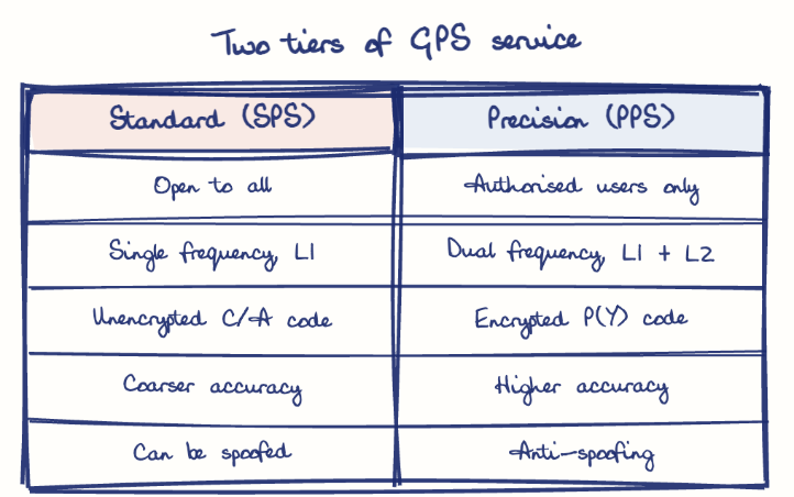
SPS is the free, unencrypted civilian signal used by phones and vehicles, which the US degraded at will through Selective Availability until May 2000.
Precise Positioning
PPS is the encrypted, dual-frequency military tier that cancels ionospheric error and resists jamming and spoofing.
India's mirror
IRNSS likewise offers an open Standard Positioning Service and an encrypted Restricted Service for the armed forces.
Seven satellites suffice
Three geostationary and four inclined geosynchronous satellites stay above the region, so all are visible from India, unlike the 24-plus global GPS fleet.
Strategic autonomy
The Restricted Service assures guidance for missiles, troops and ships even if a foreign system is switched off.
Regional accuracy
ISRO designed it for accuracy better than 20 metres over India and 1,500 km beyond, with a dual-frequency signal suited to the tropics.
Civilian uses
NavIC runs AIS-140 vehicle trackers, sends sea warnings to fishermen after Cyclone Ockhi in 2017, and reached smartphones through Qualcomm chipsets from 2019.
This model answer is indicative and the model can make mistakes; please verify key facts independently.
Practise this question
1Get the answer sheet
Sized for this question.
2Write your answer
Timed, by hand.
3Get it marked
Your score and what to fix.
This chapter in the exam
Space8 questions
Asked in 8 of 14 sittings since 2013
- 2026Mention salient features of 'Mission Drishti'. Discuss the imaging techniques used in the satellite launched on 3rd May 2026. Why it is being considered world's first satellite of its kind? (Answer in 250 words)
- 2024What are asteroids? How real is the threat of them causing extinction of life? What strategies have been developed to prevent such a catastrophe?
All 8 questions, sorted by sub-topic, with model answers and practice.
Question from the official UPSC Civil Services (Main) Examination 2015 paper. Answer written by Ghissu's engine and checked against our editorial standards. Found an error? Tell us and we correct it within 48 hours.