The "Ministry of Panchayti Raj" of Govt. of India has launched "SVAMITVA" scheme for mapping of land records. Elaborate the role of space technology to help in accomplishing the goal of the scheme.
In short
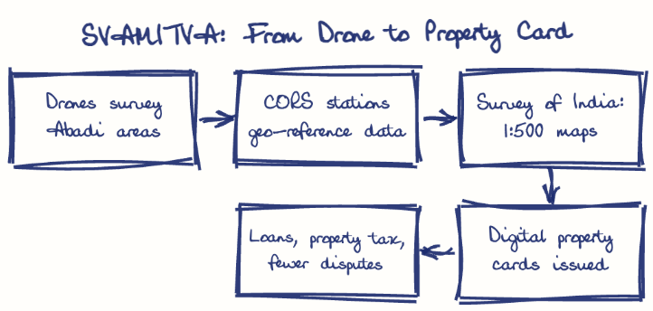
Under SVAMITVA (2020), survey-grade drones and a CORS geo-referencing network map rural inhabited (Abadi) areas at 1:500 scale with 3-5 cm accuracy, and the Survey of India turns this data into legal property cards. These records enable loans against property, Panchayat property taxes, village planning and fewer land disputes.
Model answer
Ghissu Editorial · Verified 4 Oct 2026 · 267 words
Drone Surveys for Accurate Mapping
The scheme uses survey-grade drones with high-resolution sensors to map rural inhabited areas precisely, overcoming traditional survey limitations. This method enables rapid data collection with an accuracy of 3-5 centimeters, significantly improving land parcel demarcation.
Real-Time Data Sharing
Platforms like ISRO’s Bhuvan Panchayat enable online access to geospatial data, facilitating coordination and data-driven rural development. This supports Gram Panchayats in property tax assessment and local planning.
Financial Empowerment of Rural Owners
Verified property ownership allows landowners to use land as collateral, promoting financial inclusion and access to credit. This reduces rural poverty and encourages investment in land.
Enhancing Panchayat Revenue
Accurate mapping aids property tax collection, increasing Gram Panchayats’ resources for local development. This strengthens decentralized governance and improves infrastructure delivery.
Expand Drone Surveys in ==Telangana==
Achieve full land record digitization by covering remaining villages, ensuring comprehensive rural mapping and ownership clarity.
Strengthen GIS Use in Local Governance
Build Gram Panchayats’ capacity for planning and tax management using GIS data, enabling better resource allocation and development outcomes.
This model answer is indicative and the model can make mistakes; please verify key facts independently.
Practise this question
1Get the answer sheet
Sized for this question.
2Write your answer
Timed, by hand.
3Get it marked
Your score and what to fix.
This chapter in the exam
Space applications, disasters and climate4 questions
Asked in 2 of 2 sittings since 2016
Most tested: Space technology for governance applications, especially land records and agricultural insurance.
- 2024In 2016, "Pradhan Mantri Fasal Bima Yojana (PMFBY)" was launched by Govt. of India as an insurance services for farmers for their yield. Describe the role of space technology used in this scheme.
- 2024What is Biodiversity? How does Climate Change affect biodiversity? Highlight the various conservation measures taken by the Government of India to protect biodiversity.
All 4 questions, sorted by sub-topic, with model answers and practice.
Question from the official TGPSC Group-I Mains 2024 paper. Answer written by Ghissu's engine and checked against our editorial standards. Found an error? Tell us and we correct it within 48 hours.