2016 · GS Paper 1 · Q18 · 12 marks
Present an account of the Indus Water Treaty and examine its ecological, economic and political implications in the context of changing bilateral relations.
In short
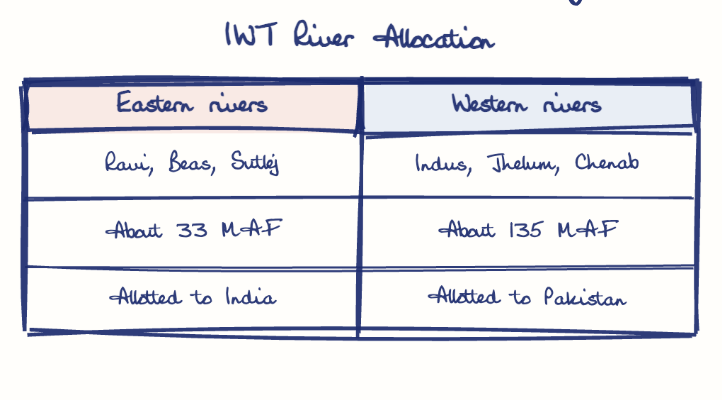
The Indus Waters Treaty of 1960 gave India the eastern rivers and Pakistan the western ones, and its ecological, economic and political stakes now track a hostile bilateral relationship. After the Pahalgam attack of April 2025, India held the treaty in abeyance.
Model answer
Ghissu Editorial · Verified 4 Oct 2026 · 303 words
Core bargain
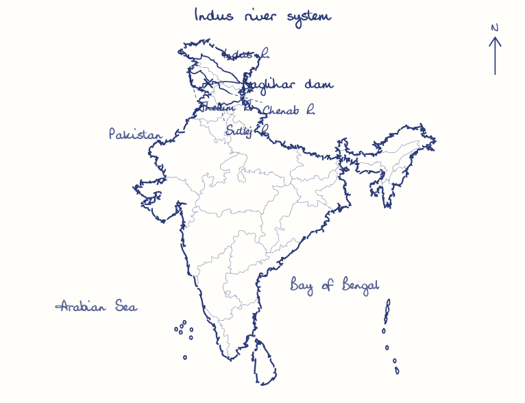
India received the eastern rivers outright, and on the western rivers may only build run-of-river hydro projects with limited storage and irrigation.
Dispute machinery
A Permanent Indus Commission shares data, and disputes go to a Neutral Expert (Baglihar, 2007) or a Court of Arbitration (Kishenganga, 2013, which fixed a minimum flow of 9 cumecs).
Ecological
The treaty ignores glacier retreat, groundwater and pollution, leaving both sides exposed in a warming basin.
Economic
The Shahpur Kandi dam (2024) now holds back unused Ravi water, and Chenab projects such as Pakal Dul and Ratle unlock hydropower, which Pakistan, dependent on Indus irrigation, sees as a threat.
Political
India served modification notices in 2023 and 2024 and held the treaty in abeyance after the Pahalgam attack of April 2025; Pakistan called any stoppage of water an act of war.
Strategic precedent
As a lower riparian facing China's planned 60 GW Medog dam on the Brahmaputra (MP-IDSA, 2024), India must weigh the norms its Indus stance sets.
This model answer is indicative and the model can make mistakes; please verify key facts independently.
Practise this question
1Get the answer sheet
Sized for this question.
2Write your answer
Timed, by hand.
3Get it marked
Your score and what to fix.
This chapter in the exam
Resources and planning38 questions
Asked in 14 of 14 sittings since 2013
- 2026"Water resources are both an asset and a source of conflict in South Asia." Examine this statement giving examples.
- 2026Analyze the role of satellite-based technologies in achieving climate-smart agriculture and food security in India.
All 38 questions, sorted by sub-topic, with model answers and practice.
Question from the official UPSC Civil Services (Main) Examination 2016 paper. Answer written by Ghissu's engine and checked against our editorial standards. Found an error? Tell us and we correct it within 48 hours.