2018 · GS Paper 1 · Q4 · 10 marks
Why is Indian Regional Navigational Satellite System (IRNSS) needed ? How does it help in navigation ?
In short
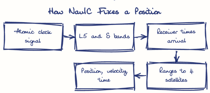
India needs IRNSS (NavIC) for strategic autonomy from foreign systems like GPS, for disaster alerts, transport tracking and precise national timing. It navigates by timing signals from seven geostationary and geosynchronous satellites on L5 and S bands, giving accuracy better than 20 metres.
Model answer
Ghissu Editorial · Verified 4 Oct 2026 · 275 words
Strategic autonomy
GPS, GLONASS, Galileo and BeiDou answer to their owners, so an encrypted Restricted Service lets India's forces navigate and guide weapons without foreign permission.
Disaster safety
Its messaging service can push cyclone and tsunami warnings to fishermen beyond mobile coverage.
Economy and timing
The AIS-140 vehicle-tracking standard builds in IRNSS receivers, and onboard atomic clocks give a national time reference for power grids, telecom and banking.
Ranging by time
Each satellite broadcasts its position and a time stamp; the receiver turns travel time into distance and, with four satellites, fixes its location and clock error.
Favourable geometry
Three geostationary and four inclined geosynchronous satellites stay constantly visible over India, supporting a designed accuracy better than 20 metres.
Dual-frequency correction
Using both L5 and S bands lets receivers remove ionospheric delay, a large error at low latitudes, while the ISRO Navigation Centre at Byalalu uploads orbit and clock corrections.
This model answer is indicative and the model can make mistakes; please verify key facts independently.
Practise this question
1Get the answer sheet
Sized for this question.
2Write your answer
Timed, by hand.
3Get it marked
Your score and what to fix.
This chapter in the exam
Resources and planning38 questions
Asked in 14 of 14 sittings since 2013
- 2026"Water resources are both an asset and a source of conflict in South Asia." Examine this statement giving examples.
- 2026Analyze the role of satellite-based technologies in achieving climate-smart agriculture and food security in India.
All 38 questions, sorted by sub-topic, with model answers and practice.
Question from the official UPSC Civil Services (Main) Examination 2018 paper. Answer written by Ghissu's engine and checked against our editorial standards. Found an error? Tell us and we correct it within 48 hours.