2022 · GS Paper 1 · Q11 · 15 marks
The political and administrative reorganization of states and territories has been a continuous ongoing process since the mid-nineteenth century. Discuss with examples.
In short
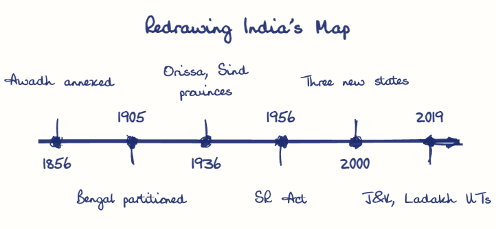
State reorganisation has been continuous since the 1850s, moving from colonial annexation and administrative convenience to language, ethnicity and development as its basis. Examples run from Awadh's 1856 annexation and Bengal's 1905 partition to the 1956 Act, Telangana in 2014 and the J&K split in 2019.
Model answer
Ghissu Editorial · Verified 4 Oct 2026 · 292 words
Annexation and lapse
Dalhousie's Doctrine of Lapse absorbed Satara, Jhansi and Nagpur, and Awadh was annexed in 1856, redrawing the map for revenue and control.
Administrative carving
The Central Provinces (1861) and a separate Assam (1874) were carved out of unwieldy units.
Partition and first linguistic units
Curzon's 1905 partition of Bengal was annulled in 1911, Bihar and Orissa became a province in 1912, and Orissa became the first linguistic province in 1936.
Integration and language
Over 560 princely states were merged, and Andhra (1953), the 1956 Act, Maharashtra and Gujarat (1960) and Haryana (1966) followed linguistic movements.
Ethnic and frontier phase
The 1971 North-Eastern Areas Act, Sikkim (1975) and Mizoram and Arunachal Pradesh (1987) answered tribal and strategic concerns.
Development phase
Chhattisgarh, Uttarakhand, Jharkhand (2000), Telangana (2014) and the 2019 split of J&K left 28 states and 8 UTs.
Clear criteria
A Second States Reorganisation Commission should test viability and identity before demands like Vidarbha are judged.
Sub-state autonomy
Sixth Schedule councils such as the Bodoland Territorial Region can meet aspirations without new borders.
This model answer is indicative and the model can make mistakes; please verify key facts independently.
Practise this question
1Get the answer sheet
Sized for this question.
2Write your answer
Timed, by hand.
3Get it marked
Your score and what to fix.
This chapter in the exam
Reorganization of States (the "Linguistic" Phase)3 questions
Asked in 3 of 14 sittings since 2013
Question from the official UPSC Civil Services (Main) Examination 2022 paper. Answer written by Ghissu's engine and checked against our editorial standards. Found an error? Tell us and we correct it within 48 hours.