2023 · GS Paper 1 · Q6 · 10 marks
How are the fjords formed? Why do they constitute some of the most picturesque areas of the world?
In short
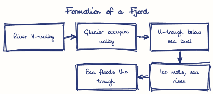
Fjords form when Pleistocene glaciers deepen river valleys into U-shaped troughs below sea level, which the sea floods after the ice melts. Norway's Sognefjord, over 1,300 m deep, shows the scale, while sheer cliffs, hanging-valley waterfalls and calm water explain their beauty.
Model answer
Ghissu Editorial · Verified 4 Oct 2026 · 273 words
River valley stage
Most fjords began as V-shaped river valleys running down to the coast before the Pleistocene ice ages.
Glacial overdeepening
Valley glaciers deepened them by plucking and abrasion into U-shaped troughs far below sea level; Norway's Sognefjord is over 1,300 m deep.
Sill and drowning
A shallow rock or moraine sill formed at the mouth where the glacier thinned, and post-glacial sea-level rise of about 120 m flooded the trough.
Sheer relief
Cliffs rise almost straight from deep water for hundreds of metres, as Mitre Peak does at Milford Sound to about 1,690 m.
Waterfalls
Hanging valleys pour waterfalls down the walls, like the Seven Sisters in Geirangerfjord.
Mirror-calm water
Sheltered from ocean swell by the sill, the still, dark water reflects snow peaks, glaciers and forests in the long, low light of high latitudes.
Heritage status
UNESCO lists the West Norwegian Fjords (2005) and Fiordland within Te Wahipounamu (1990) as World Heritage, drawing large cruise and adventure tourism.
This model answer is indicative and the model can make mistakes; please verify key facts independently.
Practise this question
1Get the answer sheet
Sized for this question.
2Write your answer
Timed, by hand.
3Get it marked
Your score and what to fix.
This chapter in the exam
Landforms5 questions
Asked in 5 of 14 sittings since 2013
- 2026Discuss the role of aeolian processes in desertification and land degradation.
- 2022Describe the characteristics and types of primary rocks.
All 5 questions, sorted by sub-topic, with model answers and practice.
Question from the official UPSC Civil Services (Main) Examination 2023 paper. Answer written by Ghissu's engine and checked against our editorial standards. Found an error? Tell us and we correct it within 48 hours.