What are the salient features of IRS-P5 ?
In short
IRS-P5, or Cartosat-1, is an ISRO cartography satellite in a 618 km sun-synchronous orbit carrying two panchromatic cameras of 2.5 m resolution that capture same-pass stereo images over a 30 km swath. Launched on 5 May 2005 by PSLV-C6 from Sriharikota, it produced the national CartoDEM.
Model answer
Ghissu Editorial · Verified 4 Oct 2026 · 348 words
Orbit
It moves in a sun-synchronous polar orbit at about 618 km, passing over each place at about the same local time and so giving uniform lighting for mapping.
Platform
The satellite weighed about 1,560 kg, was launched along with HAMSAT and had a design life of about five years.
Revisit
Steerable viewing gave a revisit of about 5 days over an area, useful for quick follow-up imaging.
Twin PAN cameras
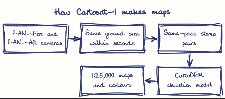
PAN-Fore and PAN-Aft cameras, tilted at about +26 and -5 degrees, view the same ground from two angles within seconds to create along-track stereo pairs, avoiding errors from changing season or light.
Resolution and swath
Each camera has about 2.5 metre resolution, enough to see buildings, roads and field boundaries, and a swath of about 30 km for fast coverage.
Storage
A solid state recorder holds images until they can be sent to ground stations.
Mapping and DEMs
Its data is used for 1:25,000 scale topographic maps, contours and the national CartoDEM.
Planning
It supports urban planning, road and canal alignment, watershed and flood studies, and project planning in states like Andhra Pradesh.
Resources and disasters
It helps in land records, forest and mining monitoring, and disaster damage assessment.
Self-reliance
It reduced dependence on foreign high-resolution imagery for national mapping.
Later missions
It led to the Cartosat-2 series and Cartosat-3 with much finer resolution, and its data is used by state centres such as the Andhra Pradesh Space Applications Centre.
This model answer is indicative and the model can make mistakes; please verify key facts independently.
Practise this question
1Get the answer sheet
Sized for this question.
2Write your answer
Timed, by hand.
3Get it marked
Your score and what to fix.
This chapter in the exam
Indian Space Programme, ISRO, Satellites and DRDO23 questions
Asked in 8 of 8 sittings since 2008
Most tested: Remote sensing and satellite applications for agriculture, natural resources, and rural development.
- 2025Describe the role of the Indian Remote Sensing (IRS) satellite programme. How do these satellites assist in natural resource management?
- 2025Discuss the vision and mission of DRDO? Describe the role of DRDO in the contribution to national development.
All 23 questions, sorted by sub-topic, with model answers and practice.
Question from the official APPSC Group-I Mains 2008 paper. Answer written by Ghissu's engine and checked against our editorial standards. Found an error? Tell us and we correct it within 48 hours.