Describe the role of the Indian Remote Sensing (IRS) satellite programme. How do these satellites assist in natural resource management?
In short
The IRS programme, run by ISRO with NRSC as the nodal data agency, supplies repeated geospatial data for planning the use of land, water, soil, forests and coasts. Satellites like Resourcesat map land use, groundwater, erosion and disaster damage, guiding drought mitigation in Rayalaseema and coastal management in Andhra Pradesh.
Model answer
Ghissu Editorial · Verified 4 Oct 2026 · 271 words
ISRO and NRSC Leadership
ISRO runs the IRS programme with the National Remote Sensing Centre (NRSC) handling data acquisition and distribution under the Remote Sensing Data Policy 2011, balancing security with accessibility.
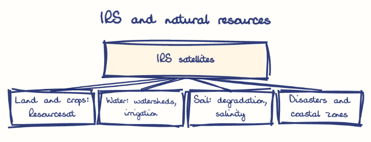
Land and Crop Monitoring
IRS satellites like Resourcesat-1 and 2A provide multispectral data for land use and crop mapping, supporting agricultural planning in Andhra Pradesh’s horticulture and chilli cultivation belts.
Water Resource Management
Satellite data aid surface and groundwater inventory, watershed management, and irrigation planning, supporting the Jal Shakti Abhiyan1 in Andhra Pradesh for drought mitigation.
Environmental and Soil Health
IRS data detect land degradation and soil salinity, aiding sustainable land management in Rayalaseema’s drought-prone areas.
Disaster and Coastal Management
IRS satellites assist early warning and coastal zone management along Andhra Pradesh’s 974 km coastline, protecting fisheries and marine ecosystems.
Enhance Data Resolution
Upgrading sensors will improve precision for localized applications in Andhra Pradesh’s agro-climatic zones.
Capacity Building
Training state agencies will empower local use of IRS data in Andhra Pradesh’s rural and coastal districts.
Integrate with Schemes
Combining IRS data with schemes like the Soil Health Card and Pradhan Mantri Fasal Bima Yojana will improve resource allocation.
This model answer is indicative and the model can make mistakes; please verify key facts independently.
Sources
Practise this question
1Get the answer sheet
Sized for this question.
2Write your answer
Timed, by hand.
3Get it marked
Your score and what to fix.
This chapter in the exam
Indian Space Programme, ISRO, Satellites and DRDO23 questions
Asked in 8 of 8 sittings since 2008
Most tested: Remote sensing and satellite applications for agriculture, natural resources, and rural development.
- 2025Discuss the vision and mission of DRDO? Describe the role of DRDO in the contribution to national development.
- 2023What is Space Junk ? Discuss the challenges posed by increased space junk and the potential risk associated with it. What do you know about Project NETRA ?
All 23 questions, sorted by sub-topic, with model answers and practice.
Question from the official APPSC Group-I Mains 2025 paper. Answer written by Ghissu's engine and checked against our editorial standards. Found an error? Tell us and we correct it within 48 hours.