Define band width. What are the different band widths used in INSAT series? Mention the significance of thermal band in Agriculture.
In short
Bandwidth is the range of frequencies a satellite channel can use, setting its data capacity, and INSAT satellites use the C, Ku, S and L bands. The thermal band measures canopy temperature to detect crop water stress and disease early, aiding irrigation and PMFBY damage assessment in Andhra Pradesh.
Model answer
Ghissu Editorial · Verified 4 Oct 2026 · 264 words
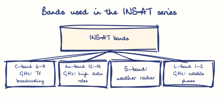
INSAT bands
C-Band (4-8 GHz) is reliable for TV broadcasting due to low rain-fade; Ku-Band (12-18 GHz) supports high-data-rate military and civilian links like GSAT-7A; S-Band (2-4 GHz) is used for weather radar and ship communication; L-Band (1-2 GHz) serves satellite phones and GPS with low rain attenuation.
Disease monitoring
Thermal imaging detects temperature changes from pathogens, enabling early crop protection and reducing yield losses.
Non-invasive crop health
Thermal sensors assess plant transpiration and stomatal conductance, aiding breeding programs and stress tolerance evaluation.
Farmer training
Krishi Vigyan Kendras (KVKs) in Andhra Pradesh help farmers interpret thermal imagery for better water and disease management, increasing adoption of remote sensing technologies.
Expand awareness
Strengthen outreach via Andhra Pradesh’s KVKs to promote thermal data use and precision agriculture practices.
Improve access
Develop platforms integrating INSAT thermal data with local advisories for real-time decision-making and wider farmer reach.
This model answer is indicative and the model can make mistakes; please verify key facts independently.
Practise this question
1Get the answer sheet
Sized for this question.
2Write your answer
Timed, by hand.
3Get it marked
Your score and what to fix.
This chapter in the exam
Indian Space Programme, ISRO, Satellites and DRDO23 questions
Asked in 8 of 8 sittings since 2008
Most tested: Remote sensing and satellite applications for agriculture, natural resources, and rural development.
- 2025Describe the role of the Indian Remote Sensing (IRS) satellite programme. How do these satellites assist in natural resource management?
- 2025Discuss the vision and mission of DRDO? Describe the role of DRDO in the contribution to national development.
All 23 questions, sorted by sub-topic, with model answers and practice.
Question from the official APPSC Group-I Mains 2012 paper. Answer written by Ghissu's engine and checked against our editorial standards. Found an error? Tell us and we correct it within 48 hours.