What is the resolution of CARTOSAT-2 and for what purpose are its images useful? What is the main difference between CARTOSAT-2 and IKONOS?
In short
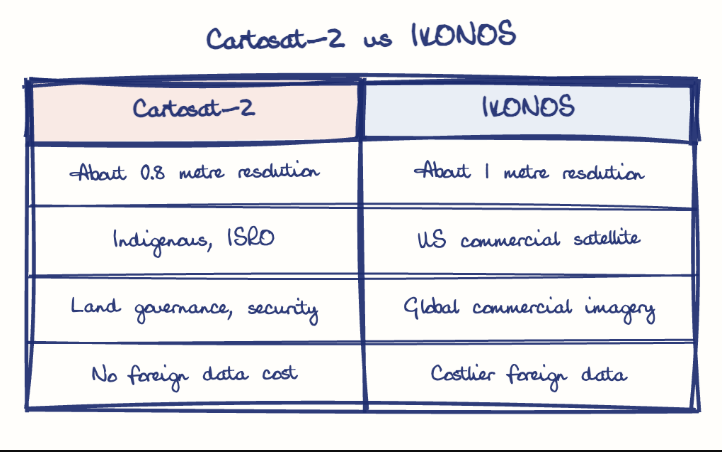
Cartosat-2 has a spatial resolution of about 0.8 metre, and its images are used for cartographic mapping, land records, urban and coastal planning, utility management and strategic surveillance. Unlike the US commercial IKONOS (about 1 metre), it is finer, indigenously built and government-controlled for India-centric use.
Model answer
Ghissu Editorial · Verified 4 Oct 2026 · 302 words
High-Resolution Imaging
Cartosat-2’s 0.8-meter resolution enables detailed mapping of land and urban infrastructure, essential for land record digitization and thematic mapping.
Multi-Purpose Applications
Its images support cartographic mapping, coastal regulation, and utility management, benefiting Andhra Pradesh’s agriculture and coastline management. These applications also assist in infrastructure monitoring and urban planning.
Limitations and Revisit Frequency
Optical sensors face cloud cover and night-time limits; revisit period is ~4 days, prompting small satellite constellations for better coverage. This limitation affects real-time monitoring during adverse weather, partially mitigated by RISAT’s radar imaging.
Comparison with IKONOS
Cartosat-2 is indigenous with 0.8-meter resolution focused on India’s strategic needs; IKONOS offers ~1-meter resolution, commercial global imagery, and higher costs. Cartosat-2’s government control ensures data security, unlike IKONOS’s commercial availability.
Enhance Satellite Constellations
Deploy small satellites to improve revisit frequency for disaster management and precision agriculture in Andhra Pradesh.
Integrate Multi-Sensor Data
Combine optical and radar data for all-weather monitoring, enhancing data reliability and operational flexibility.
This model answer is indicative and the model can make mistakes; please verify key facts independently.
Practise this question
1Get the answer sheet
Sized for this question.
2Write your answer
Timed, by hand.
3Get it marked
Your score and what to fix.
This chapter in the exam
Indian Space Programme, ISRO, Satellites and DRDO23 questions
Asked in 8 of 8 sittings since 2008
Most tested: Remote sensing and satellite applications for agriculture, natural resources, and rural development.
- 2025Describe the role of the Indian Remote Sensing (IRS) satellite programme. How do these satellites assist in natural resource management?
- 2025Discuss the vision and mission of DRDO? Describe the role of DRDO in the contribution to national development.
All 23 questions, sorted by sub-topic, with model answers and practice.
Question from the official APPSC Group-I Mains 2012 paper. Answer written by Ghissu's engine and checked against our editorial standards. Found an error? Tell us and we correct it within 48 hours.