Explain the details of Tsunami Warning System of India.
In short
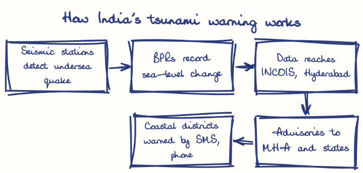
India's Tsunami Warning System, built after the 2004 tsunami and run by INCOIS Hyderabad under the Ministry of Earth Sciences, uses seismic stations, Bottom Pressure Recorders and tide gauges to detect undersea quakes. It can issue a first advisory within about 10 minutes, relayed via MHA and state emergency centres.
Model answer
Ghissu Editorial · Verified 4 Oct 2026 · 268 words
Integrated Monitoring Network
India’s system combines seismic stations and Bottom Pressure Recorders (BPRs), with four BPRs in the Bay of Bengal and two in the Arabian Sea, enabling rapid detection of seismic events and sea-level anomalies.
Data Transmission and Alert Generation
Seismic data reaches INCOIS in real time, which can issue the first tsunami advisory within about 10 minutes using satellite communication, including Iridium transceivers.
Advanced Infrastructure
INCOIS employs sophisticated sensors and computational models to analyze seismic data and predict tsunami wave propagation, supported by the Ministry of Earth Sciences.
Institutional Coordination
INCOIS coordinates with the Indian Meteorological Department and international oceanographic bodies; state-level centers like Andhra Pradesh’s State Emergency Operations Centre implement localized responses per NDMA’s Tsunami Risk Management Guidelines.
State and Central Response
The Ministry of Home Affairs and state governments disseminate warnings and coordinate evacuations; Andhra Pradesh integrates tsunami alerts into coastal disaster plans.
Operational Success and Challenges
The system successfully detected the 2007 Indonesia tsunami threat, though audits reveal gaps in buoy coverage and funding, requiring upgrades.
Network Expansion
Plans include increasing active BPRs and automated observatories, especially along Andhra Pradesh’s vulnerable coast, to improve real-time1 accuracy.
This model answer is indicative and the model can make mistakes; please verify key facts independently.
Sources
Practise this question
1Get the answer sheet
Sized for this question.
2Write your answer
Timed, by hand.
3Get it marked
Your score and what to fix.
This chapter in the exam
Development vs Environment: natural resources, climate change, EIA, natural disasters48 questions
Asked in 8 of 8 sittings since 2008
Most tested: Climate change and mining/environmental degradation links
- 2025Explain the different types of natural resources in India. How are they being conserved through government initiatives?
- 2025Investigate the relationship between mining activities and the occurrence of earthquakes. Explain how mining operations can be regulated to minimize seismic risks.
All 48 questions, sorted by sub-topic, with model answers and practice.
Question from the official APPSC Group-I Mains 2016 paper. Answer written by Ghissu's engine and checked against our editorial standards. Found an error? Tell us and we correct it within 48 hours.