To date, ISRO has launched over 100 satellites. Explain what are GEO, LEO, MEO, and SSO. Use diagrams to illustrate your answer. Add a note on GSLV and PLSV launches.
In short
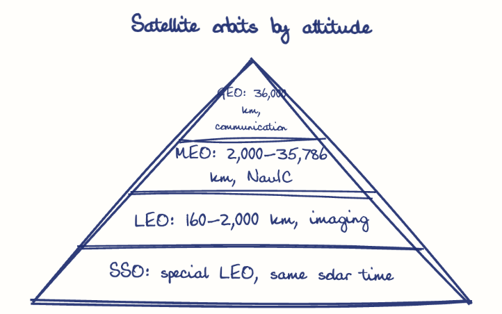
GEO satellites sit about 36,000 km above the equator for communication and weather, MEO (2,000 to 35,786 km) serves navigation, LEO (160 to 2,000 km) serves earth observation, and SSO is a polar LEO for imaging. PSLV reaches LEO and SSO, while GSLV lifts heavier payloads to GEO.
Model answer
Ghissu Editorial · Verified 4 Oct 2026 · 314 words
LEO and SSO Orbits
LEO satellites (160-2,000 km) enable high-resolution earth observation; SSO satellites maintain consistent solar timing, vital for agricultural and environmental monitoring in Andhra Pradesh. SSO’s stable lighting conditions improve data accuracy for crop and forest management.
Orbit Selection Importance
Each orbit balances altitude, coverage, and revisit time, optimizing satellite functions for communication, navigation, or observation, reflecting ISRO’s strategic deployment.
PSLV
Known for reliability, PSLV launches satellites into LEO and SSO, supporting remote sensing for agriculture and disaster management in Andhra Pradesh, with over 46 successful missions. Its versatility includes launching multiple satellites simultaneously, boosting cost-effectiveness.
Strategic and Commercial Impact
Both vehicles have reduced India’s dependence on foreign launchers and enabled ISRO’s commercial satellite launches, strengthening India’s global space market presence.
Sriharikota Launch Site
The Satish Dhawan Space Centre at Sriharikota is upgraded for multiple launches, bolstering Andhra Pradesh’s space ecosystem. Enhanced facilities support increased launch frequency and complex missions.
Regional Benefits
Satellites aid agriculture, water management, and rural broadband, aligning with Digital India initiatives and enhancing socio-economic development. Remote sensing data improves crop yield predictions and disaster preparedness in Andhra Pradesh.
This model answer is indicative and the model can make mistakes; please verify key facts independently.
Sources
Practise this question
1Get the answer sheet
Sized for this question.
2Write your answer
Timed, by hand.
3Get it marked
Your score and what to fix.
This chapter in the exam
Indian Space Programme, ISRO, Satellites and DRDO23 questions
Asked in 8 of 8 sittings since 2008
Most tested: Remote sensing and satellite applications for agriculture, natural resources, and rural development.
- 2025Describe the role of the Indian Remote Sensing (IRS) satellite programme. How do these satellites assist in natural resource management?
- 2025Discuss the vision and mission of DRDO? Describe the role of DRDO in the contribution to national development.
All 23 questions, sorted by sub-topic, with model answers and practice.
Question from the official APPSC Group-I Mains 2020 paper. Answer written by Ghissu's engine and checked against our editorial standards. Found an error? Tell us and we correct it within 48 hours.