2023 · GS Paper 1 · Q14 · 15 marks
Comment on the resource potentials of the long coastline of India and highlight the status of natural hazard preparedness in these areas.
In short
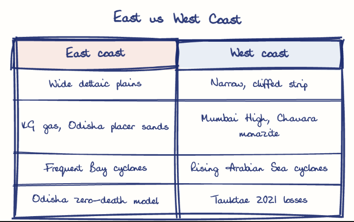
India's long coastline offers fisheries, offshore oil and gas, placer minerals, ports, offshore wind and tourism, while hazard preparedness is strong on the cyclone-hit east coast but uneven elsewhere. Odisha cut cyclone deaths from about 10,000 in 1999 to almost zero in Cyclone Yaas in 2021.
Model answer
Ghissu Editorial · Verified 4 Oct 2026 · 299 words
Fisheries
Andhra Pradesh, Gujarat and Kerala anchor marine fishing and shrimp farming, supported by PM Matsya Sampada Yojana (2020).
Energy and minerals
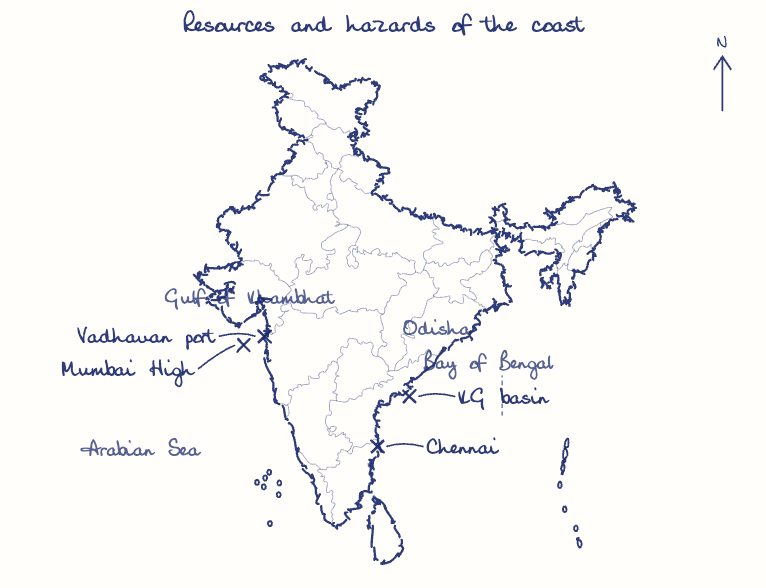
Mumbai High and the Krishna-Godavari basin yield oil and gas, while Kerala's Chavara sands hold monazite.
Ports and trade
About 95% of trade by volume moves by sea, and Sagarmala (2015) promotes port-led growth.
Renewables and tourism
Offshore wind off Gujarat and Tamil Nadu and Blue Flag beaches add new value.
Warning success
Odisha cut cyclone deaths from about 10,000 in 1999 to almost zero in Yaas (2021), and INCOIS has issued tsunami warnings since 2007.
Persisting gaps
Tauktae (2021) exposed the west coast, about a third of the coast was eroding over 1990-2018, and over 90% of losses from five major extreme events were uninsured (16th Finance Commission study, 2025).
Buffers and zoning
Restore mangroves under MISHTI and screen every Sagarmala project for hazard risk.
Last-mile model
Extend Odisha's shelters and trained village volunteers to the west coast, backed by parametric risk insurance and state mitigation funds.
This model answer is indicative and the model can make mistakes; please verify key facts independently.
Practise this question
1Get the answer sheet
Sized for this question.
2Write your answer
Timed, by hand.
3Get it marked
Your score and what to fix.
This chapter in the exam
Natural Hazards and Disasters6 questions
Asked in 5 of 14 sittings since 2013
- 2021Differentiate the causes of landslides in the Himalayan region and Western Ghats.
- 2020Account for the huge flooding of million cities in India including the smart ones like Hyderabad and Pune. Suggest lasting remedial measures.
All 6 questions, sorted by sub-topic, with model answers and practice.
Question from the official UPSC Civil Services (Main) Examination 2023 paper. Answer written by Ghissu's engine and checked against our editorial standards. Found an error? Tell us and we correct it within 48 hours.