2023 · GS Paper 1 · Q1 · 10 marks
Explain the role of geographical factors towards the development of Ancient India.
In short
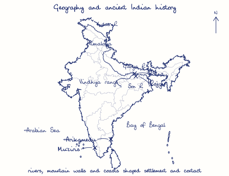
Rivers, plains, mountains and seas shaped ancient India's settlement, economy, polity and contacts, from Harappan cities on the Indus to Magadha's empire on the Ganga. Iron tools on Gangetic alluvium produced the surplus behind the Mahajanapadas, while passes and monsoon winds opened India to invaders and traders.
Model answer
Ghissu Editorial · Verified 4 Oct 2026 · 264 words
River valleys
Harappan cities rose along the Indus and Ghaggar-Hakra on flood-fed alluvium, and the drying of these rivers is a leading explanation for their decline.
Gangetic alluvium and iron
Iron tools cleared the Ganga-Yamuna forests, producing the surplus behind the Mahajanapadas and the second urbanisation of the 6th century BCE, while the monsoon set the agrarian calendar.
Magadha's advantage
R.S. Sharma linked Magadha's rise to fertile plains, nearby iron ore, war elephants and capitals protected by hills and rivers.

Himalayan shield and passes
The Himalaya sheltered the plains, but the Khyber and Bolan passes admitted Indo-Greeks and Kushanas, who brought Gandhara art.
Vindhyan divide
The Vindhyas let a distinct Sangam culture grow in the south, while the Dakshinapatha route kept it linked to the north.
Coasts and monsoon winds
Monsoon navigation drove Indo-Roman trade at Muziris and Arikamedu, recorded in the Periplus of the Erythraean Sea, and the eastern coast carried Indian scripts and temple forms to Southeast Asia.
This model answer is indicative and the model can make mistakes; please verify key facts independently.
Practise this question
1Get the answer sheet
Sized for this question.
2Write your answer
Timed, by hand.
3Get it marked
Your score and what to fix.
This chapter in the exam
Indian Culture - Ancient Times8 questions
Asked in 6 of 14 sittings since 2013
- 2026Analyze the importance of Ashokan inscriptions for reconstructing Mauryan history.
- 2024Underline the changes in the field of society and economy from the Rig Vedic to the later Vedic period.
All 8 questions, sorted by sub-topic, with model answers and practice.
Question from the official UPSC Civil Services (Main) Examination 2023 paper. Answer written by Ghissu's engine and checked against our editorial standards. Found an error? Tell us and we correct it within 48 hours.